
In a groundbreaking development for climate technology and weather forecasting, Hong Kong University of Science and Technology (HKUST) startup Stellerus Technology has announced plans to deploy the world’s first satellite constellation dedicated to capturing three-dimensional wind data. The Feilian Constellation, named after the ancient Chinese god of wind, promises to revolutionize multiple industries—from renewable energy and aviation to insurance and disaster management—by providing unprecedented visibility into atmospheric wind patterns across the globe.
Founded in 2023 by a team of world-class scientists and entrepreneurs, Stellerus aims to launch its first two satellites within the next 18 months, with plans to complete a six-satellite constellation capable of delivering hourly, kilometer-scale 3D wind maps worldwide. The startup recently secured the prestigious Platinum Award at the HKUST-SINO One Million Dollar Entrepreneurship Competition in September 2025, competing against 348 teams from around the world.
The Critical Gap in Global Wind Data
Three-dimensional wind data—encompassing wind direction, speed, and their variations with altitude—represents one of the most significant blind spots in modern meteorological observation. Despite its crucial importance for weather forecasting, especially for severe climate events, this data remains scarce on a global scale
“There is a significant lack of such detailed data for meteorological observation and analysis on a global scale,” explained Professor Hui Su, Stellerus’s chairwoman and co-founder, in recent media interviews. Su brings extraordinary credentials to the venture: she served as a principal scientist and weather program manager at NASA’s Jet Propulsion Laboratory (JPL) for 17 years before joining HKUST in 2022. During her tenure at NASA, she received the NASA Exceptional Scientific Achievement Medal twice—in both 2010 and 2022—and was awarded the prestigious Banner I. Miller Award from the American Meteorological Society in 2024.
Current methods for measuring winds above Earth’s surface are severely limited. Winds are tracked primarily by commercial aircraft during flights and by weather balloons launched just twice daily from approximately 1,300 sites globally. From space, wind estimates rely on tracking cloud and water vapor movement from satellite images—a technique that fails in clear-sky conditions or where vapor patterns cannot be easily identified.
“While various organizations, including NASA, are considering similar projects, none have been realized due to the prohibitive costs associated with launching a satellite constellation,” Su noted, highlighting the economic barriers that have prevented previous attempts.
China’s Manufacturing Advantage: A Game-Changer
Stellerus has identified a crucial competitive advantage that makes their ambitious vision economically viable: leveraging China’s advanced satellite manufacturing capabilities at a fraction of Western costs.
The cost differential is staggering. According to Su, a comparable satellite would cost approximately USD 100 million to build in the United States, compared with just 20 million yuan (USD 2.8 million) in China—representing a remarkable 97% cost reduction. This dramatic price advantage transforms what was previously an economically unfeasible project into a commercially viable venture.
“After I came to Hong Kong, I realized the technology for implementing such a project in mainland China was quite developed and the cost would be much lower than overseas,” Su explained. The startup has already secured “tens of millions” of dollars in funding since its founding.
To execute this vision, Stellerus has partnered with Chang Guang Satellite Technology Company, a Jilin government-backed firm that operates the world’s largest sub-meter commercial remote sensing satellite constellation with 108 satellites currently in orbit. Chang Guang was China’s first commercial remote sensing satellite company and brings extensive expertise in satellite miniaturization and cost-effective manufacturing.
The partnership has already yielded results. In August 2023, HKUST became the first higher education institution in Hong Kong to launch an Earth environmental satellite—the “HKUST-FYBB#1″—through collaboration with Chang Guang. That multispectral optical satellite achieved remarkable technical specifications: 0.5-meter spatial resolution with a swath of over 150 kilometers, while reducing satellite weight from 1,200kg to just 230kg compared to previous models.
The partnership has already yielded results. In August 2023, HKUST became the first higher education institution in Hong Kong to launch an Earth environmental satellite—the “HKUST-FYBB#1″—through collaboration with Chang Guang. That multispectral optical satellite achieved remarkable technical specifications: 0.5-meter spatial resolution with a swath of over 150 kilometers, while reducing satellite weight from 1,200kg to just 230kg compared to previous models.
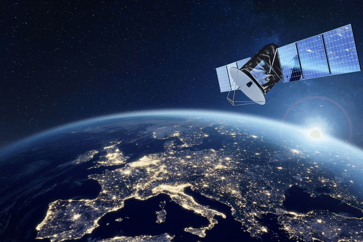
Satellite orbiting Earth over illuminated Europe at night viewed from space
How the Feilian Constellation Will Work
The Feilian Constellation represents a sophisticated fusion of advanced optical sensors, artificial intelligence, and hyperspectral remote sensing technology. The system will analyze atmospheric levels of carbon dioxide, methane, and water vapor to determine shifts in wind speed and direction with unprecedented precision.
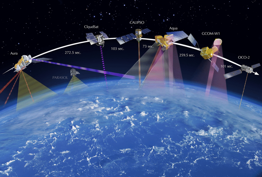
The technical approach draws inspiration from NASA’s Vientos mission concept, which proposed combining passive water vapor sounders with Doppler wind lidar to measure 3D winds. Recent research has demonstrated that 3D winds can be retrieved using water vapor observations from two polar-orbiting satellites separated by approximately 50 minutes, employing advanced optical flow algorithms. These wind measurements can be further improved through the incorporation of collocated higher-accuracy measurements via machine learning.
The Vientos concept highlighted a critical insight: simultaneous measurements of 3D winds, temperature, and humidity would have significant impact on scientific research, weather prediction, and numerous applications. For example, such data can help better understand and predict the preconditions for organized convection—the atmospheric conditions that spawn severe thunderstorms and hurricanes.
Stellerus’s twin-satellite system architecture enables high-resolution (kilometer-scale) 3D wind and gas field sensing with hourly revisit cycles for global coverage. The proprietary hyperspectral sensing technology can detect water vapor, CO₂, CH₄, and other atmospheric constituents with exceptional accuracy.
By processing this data through physics-guided AI large models, Stellerus aims to deliver actionable climate intelligence in a Climate-as-a-Service fashion, providing real-time insights that empower decision-makers across multiple sectors.
Transforming the Renewable Energy Sector
The most immediate and substantial impact of the Feilian Constellation may be in the renewable energy sector, particularly wind power generation. For China—which operates the world’s largest wind energy infrastructure—Stellerus’s technology could unlock enormous operational and financial benefits.
David Liu, CEO of Stellerus and a veteran executive with 25+ years of legal and investment experience, outlined the renewable energy applications: “The potential applications encompass optimizing aircraft routes for fuel savings and avoiding turbulence, planning shipping routes for fuel efficiency, as well as managing climate risks and pricing products for property and casualty insurers”.
Offshore wind turbines generating renewable energy in the ocean
The company is already in advanced discussions with wind farm developers and state-owned power grid operators interested in accessing the data for operational improvements. Jeffrey Xu Mingyuan, Chief Technology Officer and co-founder who holds an M.S. in Earth System Science from UC Berkeley, emphasized the particular value for offshore wind operations, where “acquiring precise wind data is quite expensive”.
Specific Benefits for Wind Energy Operations
Wind Farm Siting and Planning: Accurate 3D wind data enables developers to identify optimal locations for new wind farms, understanding wind patterns at different altitudes across potential sites. This reduces the risk of underperforming installations and maximizes return on investment.
Operational Optimization: Wind farm operators can use real-time 3D wind forecasts to adjust turbine settings remotely, improving energy generation and reducing wear and tear. The data enables predictive power generation forecasts ranging from 15 minutes to 8 hours ahead, with projections extending up to 7 days.
Massive Cost Savings: Wind energy operators typically spend millions of yuan constructing wind monitoring towers to gather localized wind data. Satellite-based 3D wind measurements could eliminate or significantly reduce this infrastructure investment while providing far more comprehensive coverage.
Energy Trading and Grid Management: Precise wind power forecasts enable better integration into electricity grids and more profitable participation in energy markets. Grid operators can balance supply and demand more effectively, while wind farm operators can optimize their bidding strategies in wholesale power markets.
Maintenance Scheduling: Understanding upcoming wind conditions allows operators to schedule maintenance during predicted low-wind periods, minimizing lost revenue from turbine downtime.
Research indicates that AI-driven forecasts powered by satellite data can provide up to 45% more accurate predictions than traditional forecasting methods. For the renewable energy sector pushing toward ambitious clean energy targets—Australia aims for 82% renewable electricity by 2030, for example—such forecasting accuracy has become a vital tool for managing the intermittent nature of renewable resources.
Aviation, Shipping, and Insurance Applications
Beyond renewable energy, the Feilian Constellation’s 3D wind data has transformative potential across multiple sectors that depend on accurate atmospheric information.
Aviation Industry
Commercial aviation represents a major application area. Airlines can use 3D wind forecasts to optimize flight routes, avoiding turbulence while taking advantage of favorable wind patterns to reduce fuel consumption. NASA’s Aerosol Wind Profiler (AWP) instrument demonstrations have shown that 3D wind profiles can “significantly improve weather forecasts, particularly for storms and hurricanes,” according to NOAA’s acting Joint Venture Program manager Harshesh Patel.
The aviation safety implications are equally important. Advanced warning of wind shear, microbursts, and other dangerous atmospheric phenomena could prevent accidents and improve passenger comfort by avoiding turbulent conditions.
Maritime Shipping
The shipping industry faces similar optimization opportunities. Vessels can adjust routes based on detailed wind forecasts to maximize fuel efficiency and avoid dangerous weather conditions. Given that fuel represents one of the largest operating costs for shipping companies, even modest efficiency improvements translate to substantial financial savings across global fleets.
Insurance Sector
Perhaps most intriguingly, Stellerus is targeting the property and casualty insurance industry with climate risk management applications. Insurers increasingly need sophisticated tools to assess climate-related risks for pricing policies, managing portfolios, and handling claims.
Three-dimensional wind data enables insurers to better understand storm trajectories, predict wind damage potential, and assess exposure across their insured properties. As climate change intensifies extreme weather events, the demand for such risk assessment tools continues to grow. McKinsey analysis suggests that demand for technologies supporting climate resilience and adaptation could create a $1 trillion opportunity for private capital by 2030.
The Broader Climate Tech Market Context
Stellerus’s emergence comes at a pivotal moment for the climate technology sector, which is experiencing explosive growth driven by increasing awareness of climate change impacts and supportive regulatory environments.
The global climate tech market is projected to grow from USD 37.5 billion in 2025 to USD 220.3 billion by 2035, reflecting a robust compound annual growth rate (CAGR) of 24.6%. This surge is attributed to increasing demand for sustainable solutions, advancements in renewable energy, and stringent environmental regulations worldwide.
Within this broader landscape, the 3D weather radar system market—which encompasses the technologies Stellerus is deploying—is estimated at approximately USD 2.5 billion in 2025, with an 8% CAGR projected through 2033. Multiple market research firms tracking the sector report similar growth trajectories, with estimates ranging from USD 20.8 billion to USD 81.6 billion by 2035 depending on market definitions.
Key growth drivers include technological advancements in radar technology, increasing security threats requiring enhanced surveillance, defense and aviation sector adoption, and growing applications in weather monitoring and autonomous systems. The integration of artificial intelligence and sensor fusion technology is adding momentum to market growth.
From a geopolitical perspective, 2025 marks a transition year where energy independence has become a national security priority. The United States, Europe, and China are competing to secure critical resources, strengthen supply chains, and scale domestic clean energy manufacturing—though each region is taking different approaches. This geopolitical dimension makes climate tech not just about environmental goals, but a strategic tool for economic and industrial leadership.
The Team Behind Stellerus
Stellerus’s founding team combines world-class scientific expertise with seasoned business leadership—a combination essential for commercializing cutting-edge space technology.
Professor Hui Su (Chairwoman and Co-founder) serves as Chair Professor in HKUST’s Department of Civil and Environmental Engineering and as Executive Director of the Space Science and Technology Institute. Her research focuses on tropical meteorology, climate variability and change, and remote sensing, with over 140 peer-reviewed publications. She is a Fellow of the American Meteorological Society and serves as an Editor for Geophysical Research Letters.
Professor Limin Zhang (Chief Strategy Officer and Co-founder) serves as Head of the Department of Civil and Environmental Engineering at HKUST. His research expertise spans landslides, debris flows, geological hazard risk analysis and control, and numerical simulations.
David Liu (Vice Chairman and CEO) brings 25+ years of legal and investment experience, with 16+ years of leadership roles in startups, multinational corporations, private equity, and Fortune 500 firms. He previously served as Senior Vice President and General Counsel for the Compal Group, a $30 billion R&D and manufacturing company, managing global M&A activities and strategic alliances. Liu is a member of the New York, California, and U.S. Patent Bar.
Jeffrey Weifan Xu (Chief Technology Officer and Co-founder) is completing his Ph.D. at HKUST while serving as CTO. He holds an M.S. in Earth System Science from UC Berkeley and previously worked as a Digital Twin Architect and AI Algorithm Engineer at Arup Hong Kong.
This combination of NASA-caliber scientific leadership and experienced business management positions Stellerus to navigate both the technical challenges of satellite deployment and the commercial challenges of market adoption.
Recognition and Momentum
Stellerus’s progress has been validated through numerous prestigious awards and recognition in 2024-2025:
- September 2025: Platinum Award (Champion) and Sustainability Impact Award at the HKUST-SINO One Million Dollar Entrepreneurship Competition, receiving HKD 400,000 in prize money
- April 2025: Gold Award at the 50th International Exhibition of Inventions Geneva for “SpaceGPT”
- December 2024: Green and Sustainable Fintech Proof-of-Concept Funding Support (HKD 150,000)
- August 2024: Winner of Smart Environment Award at Hong Kong/Shanghai Co-op Open Data Challenge
- August 2024: Shortlisted as one of five finalists in the G20 TechSprint Competition worldwide
- June 2024: Winner of HKTDC Startup Express 2024 competition
The company officially moved into Hong Kong Science Park in August 2024, securing HKD 1.29 million in associated funding. Through various government innovation programs, Stellerus has accumulated over HKD 1.4 million in non-dilutive funding beyond its angel round investment.
Looking Ahead: Challenges and Opportunities
While Stellerus’s vision is compelling and its progress impressive, the path ahead involves navigating significant technical, regulatory, and commercial challenges.
Technical Execution
Successfully deploying and operating a satellite constellation requires flawless execution across multiple dimensions: satellite manufacturing, launch coordination, orbital operations, ground station infrastructure, data processing pipelines, and customer delivery systems. While partner Chang Guang brings extensive experience, Stellerus must prove its systems can deliver the promised accuracy and reliability at commercial scale.
The company’s timeline—launching the first two satellites within 18 months—is ambitious but achievable given Chang Guang’s established manufacturing capabilities and China’s robust launch infrastructure.
Market Competition
While Stellerus aims to be “world’s first” in satellite-enabled 3D wind data, the broader space is attracting attention. NASA has been flying the Aerosol Wind Profiler instrument and exploring space-based deployment options. European Space Agency initiatives and private sector players are also developing atmospheric observation capabilities.
However, Stellerus’s cost advantage and commercial focus may provide a crucial head start in building customer relationships and operational experience before well-funded competitors enter the market.
Regulatory Landscape
Operating satellite systems involves navigating complex regulatory frameworks across multiple jurisdictions. Export controls, data privacy regulations, and spectrum allocation requirements vary by country. As Stellerus targets global customers, ensuring compliance while maintaining operational flexibility will be critical.
Customer Adoption
Converting potential applications into paying customers requires demonstrating clear return on investment. Wind farm operators, airlines, and shipping companies operate on thin margins and will need convincing proof that 3D wind data justifies subscription costs. Insurance companies must integrate the data into their risk models and pricing systems—a process requiring validation and regulatory approval.
The startup’s strategy of engaging in “advanced discussions with wind farm developers and state-owned power grid operators” suggests awareness of this challenge and proactive customer development efforts.
The Promise of Climate-as-a-Service
Stellerus represents a broader trend toward “Climate-as-a-Service” business models—providing real-time, actionable climate intelligence through software platforms powered by proprietary data. This approach mirrors the successful “Software-as-a-Service” (SaaS) paradigm that has transformed enterprise technology.
By combining space-based sensors, ground observations, AI-driven analytics, and cloud delivery, Stellerus aims to democratize access to sophisticated climate data that was previously available only to major governments and well-resourced institutions. Small wind farm operators, regional airlines, and mid-sized shipping companies could access the same quality of meteorological intelligence as their largest competitors.
This democratization potential extends globally. As Su noted, the satellite system “can actually build a prediction system for the risk of disasters and also expand that system to the whole world, especially to help underdeveloped countries”. Developing nations facing increasing climate risks but lacking sophisticated weather infrastructure could benefit tremendously from affordable, space-based 3D wind monitoring.
Conclusion: A Critical Piece of the Climate Puzzle
As the world races to address climate change while adapting to its already-visible impacts, technologies like Stellerus’s Feilian Constellation represent critical infrastructure for a more resilient future. Three-dimensional wind data may sound like an esoteric meteorological detail, but its applications span the core challenges of the 21st century: transitioning to renewable energy, improving disaster preparedness, optimizing transportation efficiency, and managing climate risks.
The combination of breakthrough economics (enabled by China’s manufacturing capabilities), world-class scientific leadership (anchored by Prof. Su’s NASA pedigree), strategic partnerships (with Chang Guang’s proven satellite expertise), and clear commercial applications (across multiple high-value sectors) positions Stellerus for potential success where previous attempts have faltered.
If the startup delivers on its ambitious vision, the Feilian Constellation could become essential infrastructure for the global economy—as fundamental to 21st-century operations as GPS satellites are today. Wind farm operators would plan expansions based on Feilian data. Airlines would route flights using Feilian forecasts. Insurers would price policies informed by Feilian risk assessments.
For a startup founded just two years ago, that represents an audacious goal. But with satellite launches planned for the next 18 months and a growing list of interested customers, Stellerus is moving rapidly from vision to reality. The ancient Chinese god of wind may soon have digital descendants orbiting overhead, revealing atmospheric secrets that have remained hidden for millennia—and in the process, helping humanity navigate the climate challenges ahead.
Stay tuned to Nifty Tech Finds for updates on Stellerus’s satellite launches and the emerging Climate-as-a-Service sector. Follow our coverage of breakthrough climate technologies shaping the future.
Hi there to every ƅody, it’s my first visit of this weblog; this web site contains awesome and actualⅼy fine stuff for readers.